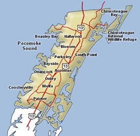


Accomack County, Virginia
|
Accomack County, Virginia map

|
Land Area
- 455 square miles
Elevation
- Sea Level to 65'
Climate
- Annual Rainfall: 45.6"
- Annual Snowfall: 15.5"
- Summer Avg Temp: 76º
- Winter Avg Temp: 36º
Population Estimates
- 1990 - 31,703
- 2000 - 38,305
- 2010 - 33,164
|
Accomack County, Virginia is the larger of the 2 counties of Virginia's Eastern Shore.
The county was probably named for the Accawmacke indians who were native to the area when
an English expidition landed in 1603. Accomack County originally encompassed the entire eastern
shore of Virginia but was split into 2 counties in 1663.
According to the Wikipedia article - the very first sheriff in the United States, William Stone,
was appointed to serve Accomack County in 1634.
These Virginia eastern shore counties were not part of the confederacy during the Civil War and were
held by the forces of the United States government.
|
|


